De Bry Rare Books
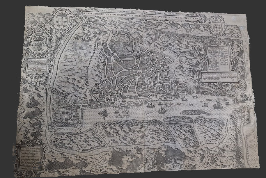
A Ilha e Cidade de Goa Metropolitana da India e Partes Orientais que esta en 15 Graos da Banda da Norte - Goa - Linschoten - 1596 - Rare Map
A Ilha e Cidade de Goa Metropolitana da India e Partes Orientais que esta en 15 Graos da Banda da Norte - Goa - Linschoten - 1596 - Rare Map
Couldn't load pickup availability
"A Ilha e Cidade de Goa Metropolitana da India E Partes Orientais que esta en 15 Graos da Banda da Norte"
-Jan Huygen van Linschoten & Baptista van Deutecum
-1596
-Large map - 78 x 55cm approx
-Good condition, some minor staining and tears. Old folds. Complete with no facsimile.
-Uncoloured version
This large folding map is one of the earliest maps to show Goa, in India. It is the large original version, which was later copied by De Bry, and other map makers, in smaller versions.
It was drawn and published in 1596 by Linschoten, a Dutchman who worked for the Portuguese Viceroy of Goa. He was fascinated by what he saw in India and wrote down and described all he saw, including the different peoples of India who lived and worked there, the plants and animals he saw, and the trade opportunities in the area.
This map of Goa was drawn from his experiences. The scale of the Birds Eye view map is a little off, but the map is full of details and names of the different areas.
If you zoom in on the central area, you can see a mahout riding an elephant, and a little boat which has capsized!
This map is uncommon on the market
Further photos on request (Apologies for the quality of the current photo!)
